Kalgoorlie Regional

ASX HRZ:

Horizon controls a number of prospective tenements within the Kalgoorlie region with these project areas including the Greater Boorara-Cannon project area, Lakewood, Binduli-Teal project area, Kalpini, Balagundi-Kanowna South and Black Flag. Together these projects fall under the Kalgoorlie Regional area.

Greater Boorara-Cannon Project area

The 100% owned Boorara Gold Project is located 15km east of Kalgoorlie-Boulder adjacent to the Super Pit and 1km southwest of the Nimbus Silver-Zinc Project site where established offices are connected to mains power and existing water supplies. The Greater Boorara-Cannon project area also encompasses the Cannon tenements located approximately 10km east of Boorara via existing roads, and also the Golden Ridge tenements 4km south of Boorara.

The Boorara deposit is hosted in a quartz dolerite comprising a sheeted quartz vein array system with bounding shear zones and late-stage cross faults. Mineralisation occurs as northwest dipping sheeted and stockwork quartz-carbonate vein arrays within the quartz dolerite host rocks, and steeply dipping zones along sheared geological contacts trending to the north-northwest.

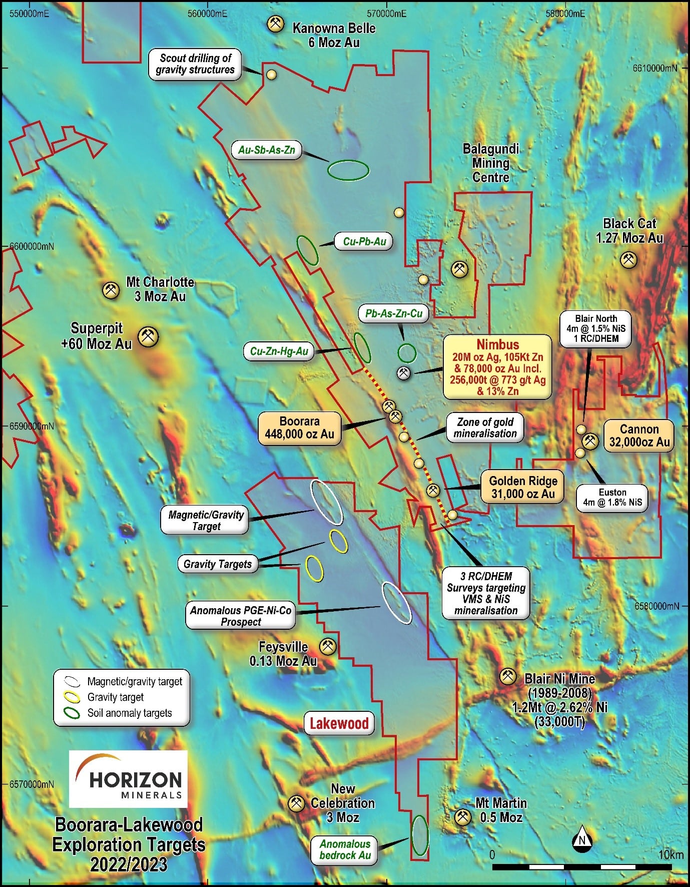
The Cannon deposit occurs within Horizon’s Bulong South gold project located 30km east-southeast of Kalgoorlie in the Eastern Goldfields region of Western Australia, on granted Mining Lease 25/333.

The Cannon deposit was discovered by Southern Gold Limited in 2008 following up geochemical anomalies testing for strike extensions of the George’s Reward mineralisation immediately north of the Bulong South deposit. The George’s Reward prospect was initially held by Northern Mining Limited and comprised an Inferred Mineral Resource of approximately 23,000 ounces when purchased by Westgold Limited in 2015.

A data review of historical work completed at the Cannon project identified two promising Nickel prospects. Five holes for 990m were drilled to test new targets and validate the historical nickel results at Euston and Blair North prospects within the Cannon Project. The first nickel hole from Euston has returned encouraging (preliminary) assay results of 4m @ >1.0% Ni, 607ppm Cu and 250ppm Co from 160m (CARC22008).

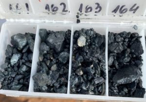
Sulphide mineralisation at Euston

The chip tray photo above provides visual confirmation of the pyrite-pentlandite mineralisation. This interval also lines up reasonably well with the historic mineralisation in BSRC041 (4m @ 1.78% Ni) and provides important vector information for the follow up drilling targeting thicker, high grade nickel mineralisation.

At the Blair north prospect, west of the Cannon mine, two drill holes aimed to validate the historic mineralisation in BNRC019 (3m @ 2.62% Ni, 542 ppm Co, 2,400 ppm Cu from 156m and 2m @ 3.94% Ni, 709 ppm Co, 1,825 ppm Cu from 161m). The holes, to 222m depth, were drilled with one of them being cased for the planned Down Hole Electro-Magnetic (DHEM) survey. Assay results for both holes are pending.

Horizon considers that both prospects (Figure 4) were not adequately followed up (due to the Cannon gold discovery) and therein presents an opportunity to focus on these open targets at depth.

In addition to drilling for Nickel-Cobolt, the Company has undertaken drilling for gold within the project area and completed 29 RC holes for 5,054m at Golden Ridge and Cannon-Monument in the March 2022 Quarter.

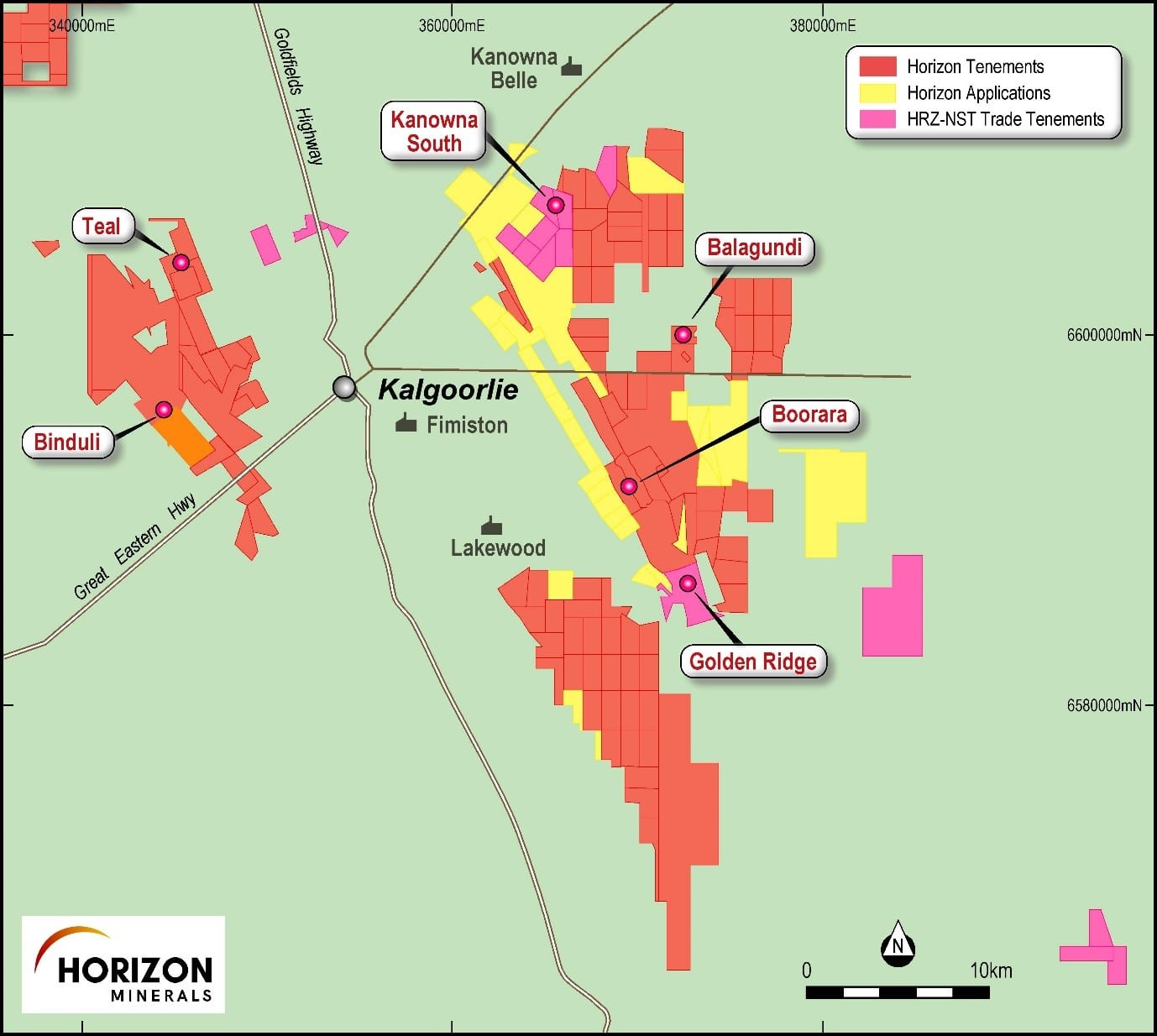
The historic Golden Ridge Gold Mine was acquired as part of the asset swap with Northern Star Resources in 2019 is contiguous and to the south of Horizon’s Boorara project. Gold is largely confined to a north-south trending, sub vertical felsic fragmental unit located between shales and cherts to the west and ultramafic sequences to the east.

Golden Ridge was first developed from 1901-1927 where 249,356t @ 17.1g/t for 139,546 oz was mined to an underground depth of 174m, with more recent open cut mining from 1998-2004 producing 1.78 Mt @ 1.98 g/t Au for 113,520 oz.

The Golden Ridge geology is largely associated with the north-south trending, sub vertical quartz-feldspar porphyry located between shales and cherts to the west and ultramafic (talc-carbonate) sequences to the east and further west. Mineralisation is similar to Boorara where gold is observed in flat lying vein arrays and thicker, steeper dipping contact style lodes.

Downhole EM surveys to support nickel and VMS drill targeting has been completed at Golden Ridge and Cannon. Three mid-late time conductors were identified at Golden Ridge. Three follow up holes were recommended by Southern Geoscience Consultants

LAKEWOOD

Lakewood is located 20km southeast of Kalgoorlie – Boulder, adjacent to Boorara and only 8km southeast of Kalgoorlie’s super pit within the Black Flag Formation with influence from the Gidji and Boorara shears, the Golden Mile dolerite and the Boulder-Lefroy fault.

The Lakewood project is extensively covered by Playa Lake sediments, aeolian deposits derived from desiccated playas and other transported Cainozoic material. Only a small portion of the Project area is covered by in-situ soils, and there is virtually no outcrop. Lakewood typically comprises a thin veneer of soils overlying plastic clays that vary in thickness from 2m – 40m. Below this are unconsolidated clays and sands and then bedrock. Sandy grey clay filled paleochannels exist within the central Project area, some of which host small amounts of alluvial gold. There has been no mining activity on the tenure.

The interpreted geology of the Lakewood project is a late-stage sedimentary basin dominated by metamorphosed sedimentary rocks and felsic volcanic/intrusive rocks of the Black Flag Formation, together with a sequence of sediments, basalts, mafic and ultramafic intrusives on the eastern edge.

Recent interpretative gravity work in 2021 by an external consultant has shown that this linear zone of mafic/ultramafic intrusives is located on a regional scale (~10mGal), deep seated (+1,600m) NNW trending, vertical dipping litho-boundary. This could be a potentially key driver as many of the Ni and Platinum Group Metals (PGM) occurrences in the Eastern Goldfields are sited close to deep crustal structures.

The Company has completed a first pass reconnaissance program comprising 59 AC holes for 3,002m testing four priority targets for nickel-cobalt and platinum group metals over a mafic/ultramafic intrusives and sediments. Initial assays were received from drilling over a mafic/ultramafic intrusive and sediments returning shallow, highly anomalous Pt-Pd-Ni-Co mineralisation in the weathered profile.

Significant composite results received to date from the key targets include:

  • 8m @ 206ppb Pt & 35ppb Pd from surface (PGM 2E 0.24g/t), 4m @ 67ppb Pt and 39ppb Pd from 8m (PGM 2E 0.11g/t)3 and 4m @ 124ppb Pt and 24ppb Pd from 24m (PGM 2E 0.14g/t) (LKAC21025)
  • 4m @ 133ppb Pt & 37ppb Pd from 20m (PGM 2E 0.17g/t), and 4m @ 90ppb Pt, 34ppb Pd and 503ppm Ni from 24m (LKAC21014)
  • 8m @ 131ppb Pt, 14 ppb Pd (PGM 2E 0.14g/t), 726ppm Ni, 119ppm Co from 20m and 4m @ 102ppm Cd from 64m, 4m @ 921ppm Cu from 68m (to end of hole) (LKAC21023)
  • 4m @ 33ppb Pt & 77ppb Pd (PGM 2E 0.11g/t), and 417ppm Ni from 32m (LKAC21020)

Very little Ni-PGM information is available on the GSWA-Wamex website relating to the historical exploration in this anomalous area (Figure 11) and, in particular, the mafic/ultramafic intrusives. Field inspection prior to drilling identified encouraging but occasional ironstone gossan float trails and shallow (gossan) pitting within a weathered ultramafic host. Both areas were drill tested with the AC rig.

Maximum 4m composite results of 259ppb Pt, 77ppb Pd, 807ppm Ni, and 162ppm Co are encouraging and combined with elevated Ag (6.58g/t), As (188ppm), Au (47ppb), Cd (102ppm), Cu (921ppm), Pb (0.12%) and Zn (0.16%) 1 suggests that the Lakewood intrusive/sedimentary complex has a genuine polymetallic signature1. Single samples have been collected and submitted for confirmation multi-element analysis.

A gravity map is shown in Figure 12 and highlights several ‘red’ gravity highs at Lakewood. Gravity maps typically demonstrate the variations between rock density units below the surface. Higher density rocks (e.g. mafic dolerite or ultramafic intrusive rocks) produce a higher gravity reading compared to low density rocks (e.g. clays, shales, siltstone). The gravity trend extends for 9km. Gravity highs in the central or western portion of Lakewood possibly represent large intrusives buried beneath the sedimentary cover. The gravity highs to the east of the litho-boundary structure also have a strong and disrupted magnetic signature. Other deep structures are clearly visible and provide a number of new and essentially untested drill targets.

Binduli - Teal project area

The 100% owned Binduli gold project area is located 9km west of Kalgoorlie – Boulder and is accessible by existing sealed and unsealed roads. The project area contains the core satellite Crake and Coote projects in the south of the tenement package and Honeyeater and Kestrel prospects to the north. The project area comprises approximately 98.8 km2 and is located immediately adjacent to the south and west of the Company’s Teal gold mine. It is also adjacent to the Frog’s Leg underground and White Foil open pit gold mines operated by Evolution Mining, and Norton Goldfields’ Janet Ivy mine.

The geology at Binduli is dominated by the Black Flag Group – a sequence of intermediate and felsic volcanics, sedimentary rocks and porphyry intrusives. Typically, the area is covered by major North North-West (NNW) shear zones cutting across the historic Binduli goldfield. Close to West Kalgoorlie are the Crake and Coote deposits which are similar to the nearby 390,000oz Janet Ivy open pit, located 1.5km south, where the gold is hosted in a structurally controlled pink feldspar porphyry. At the nearby Fort William and Fort Scott open pits, where over 100,000oz have been produced to date, gold is hosted within sheared units of volcanics and clastic sediments.

The Mineral Resource estimate (JORC 2012) for the advanced Crake deposit is 1.42Mt at 1.46g/t for 66,500oz at a 0.8 g/t Au lower cut-off grade

The Company has assessed all recent assay results from resource extension drilling at Coote and Crake, and has planned the follow up extensional programs for completion in 2022-23 including the step out and infill programs at Kestrel and Honeyeater. All new data will be compiled to generate an updated MRE for Crake and a maiden MRE for Coote expected in late 2022/early 2023.

The Teal project is located on granted Mining Leases 26/499, 26/621, 26/346, 26/549 and Miscellaneous Licence 26/261 approximately 11km northwest of Kalgoorlie in Western Australia. The Teal camp comprises three main deposits, namely Teal, Jacques Find and Peyes Farm, in addition to new discoveries made in 2018.

The geology at the Teal project area is dominated by Black Flag sediments (felsic volcanics and volcanoclastics) with lesser amounts of porphyry and intermediate volcanics. Fresh rock gold is typically associated with quartz and sulphides and faulting has displaced and pinched out some of the mineralisation. Primary mineralisation at depth exhibits semi-refractory properties and optimal recoveries are achieved through ultra-fine grinding, pressure oxidation or roasting. The shallow oxide supergene mineralisation is similar to the Teal gold mine where recoveries above 93% where achieved.

Open pit mining of Stage 1 commenced in late 2016 at the Teal deposit, and Stage 2 commencing in September 2017, with mining of both stages completed in March 2018 with final gold production occurring in the June 2018 quarter. The mine performed strongly against the feasibility study metrics with tonnes, grade, recovery and ounces up, resulting in a large increase in revenue.

Following a substantial amount of drilling, including a large 55,000 metres drilling program carried out in 2018, resources have continued to grow at Teal, Jacques Find and Peyes Farm.

The independent JORC (2012) Mineral Resource for the Teal Project, after depletion from mining Teal Stages 1 and 2, stands at:

3.55Mt @ 2.30 g/t Au for 258,140 ounces at a 1.0 and 0.8 g/t Au lower grade cut-off for Teal and Jacques Find / Peyes Farm respectively.

Further stages of the Teal project shall focus on open pit development for extraction of the supergene and transitional ore as part of the mining production pipeline for conventional milling. In addition, an assessment of the deeper sulphide mineralisation is being undertaken in conjunction with the Nimbus Silver-Zinc Project 20km to the east. The aim of this assessment is to evaluate the potential to treat the deeper Teal ore and generate a gold concentrate for sale to potential offtake partners along with a sliver and zinc concentrate from Nimbus utilising the same concentrate plant.

KALPINI

Kalpini is located approximately 65km northeast of Kalgoorlie in the Eastern Goldfields of Western Australia and 50km by existing roads to the 100% owned Boorara Gold Project. The project comprises granted Mining Lease 27/485 and Miscellaneous Licence 27/88 and covers approximately 585 hectares. The main ore deposits within the project are Gambia, Atlas and Camelia.

Stage 1 of the open pit was completed in 2019 and produced approximately 39,000oz with a mill reconciled grade of 2.62g/t Au and calculated gold recovery of 95.1%.

Gold mineralisation along the Gambia-Camelia trend has been defined over a 900m strike length and confined to multiple stacked narrow (0.5-3m) high grade flat dipping lodes hosted within gabbro. The lodes are characterised by arsenopyrite-sericite-carbonate quartz breccias that have a limited leucoxene-chlorite-carbonate alteration halo in the host gabbro. Arsenopyrite content is variable but in the high-grade lodes can be in the range 1-3%.

Importantly, all drilling along the Gambia-Camelia trend has focussed on the flat dipping lodes which are located on the central portion of the gabbro, with no drilling targeting the contact with the intermediate volcanoclastic rocks. Both the hanging and footwall contacts of the gabbro may provide the locus for shear hosted gold mineralisation, the flat narrow high-grade lodes being perhaps brittle link lodes.

The Mineral Resource estimate (JORC 2012) for Kalpini is 1.87Mt @ 2.33g/t Au for 139,000 ounces at a 0.8g/t Au lower cut-off grade.

An internal review of the geological model and recent drilling results have highlighted both the open pit and underground potential of the deposit and work commenced on compiling a new resource model on this basis.

An updated Mineral Resource Estimate (MRE) for Kalpini is expected in the December Quarter 2022 followed by mine optimisation, design and economic analysis will then follow for Ore Reserve generation thereafter.

BALAGUNDI, KANOWNA SOUTH and BLACK FLAG

The Balagundi-Kanowna South areas are also highly prospective for gold with the local geology dominated by a sedimentary sub-basin comprising shale, siltstone and greywackes that have been intruded by gabbroic sills and felsic porphyry dykes which provide additional exploration opportunities. Data review, including recent seismic data has indicated some prospective targeting of future drill programs in the area.

The Black Flag project is located about 35km NNW of Kalgoorlie and overlies part of the highly prospective Abattoir Shear Zone (Teal-Jacques-Gimlet Deposits) and arguably, the south-eastern edge of Mt Pleasant anticline. The geology is dominated by the Black Flag volcanics, sediments and porphyry intrusives.

Much of the historical (drilling) work at Black Flag was completed by Centaur Mining (1996-1998) and Placer Dome (2003-2006). This work resulted in an improved geological understanding of the area which was mostly covered by sheet wash and lake clays. There are few, if any, historical drill holes of note, the best result being 1m @ 1.24 g/t (38m) and 1m @ 4.46 g/t (46m) from BFLA553 near the interpreted Abattoir Shear.

Late in 2019, Horizon conducted a first pass 4 hole RC program at Black Flag aimed at helping improve the regolith profile understanding as well as testing selected areas where the historical drilling had discovered minor, but anomalous, levels of gold.  Significant results achieved included:

  • 1m @ 2.84 g/t Au from 41m; and
  • 1m @ 1.07 g/t Au from 23m.

Follow up drilling in 2021-2022 also discovered new prospects at Black Flag with an encouraging shallow intercepts of:

  • 8m @ 2.19g/t Au from 30m including 5m @ 3.03g/t Au from 30m (BFAC21013); and
  • 1m @ 0.55g/t Au from 14m and 1m @ 2.74g/t Au from 26m (boh, BFAC21026).

Further drilling is planned in 2024.

The Kanowna South prospect, located 5km south of the Kanowna Belle gold mine, has progressed with further encouraging gold results highlighted by recent drilling that comprised eight AC holes for 465m and twelve RC holes for 1,270m during 2023.  Significant results to date include:

  • 1m @ 5.91g/t Au from 66m in KSRC23008. Strong arsenopyrite and fuchsite mineralisation was observed.
  • 1m @ 4.40g/t Au from 46m in KSAC23002.
  • 21m @ 0.44g/t Au from 54m in KSRC23002 including 3m @ 0.74 g/t Au from 55m.
Scroll to Top